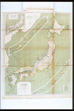
日本<大日本>地図.博士J.ライン教授の時代からと,日本とヨーロッパの地図によって,J.リッタウによって計画作図された,1880年(地図).1876年の区分による県別日本地図/(Map of Japan (Dai-Nippon). Designed and drawn from the date of Prof. Dr. J. Rein, and after Japanese and European maps by J. Rittau, 1880. Japan, according to the division of 1876.)
| caption |
: |
日本<大日本>地図.博士J.ライン教授の時代からと,日本とヨーロッパの地図によって,J.リッタウによって計画作図された,1880年(地図).1876年の区分による県別日本地図/(Map of Japan (Dai-Nippon). Designed and drawn from the date of Prof. Dr. J. Rein, and after Japanese and European maps by J. Rittau, 1880. Japan, according to the division of 1876.) |
| note |
: |
|
| book title |
: |
日本:紀行と研究:プロイセン政府の費用で請け負われた |
| author |
: |
ライン/(Rein, J. J., 1835-1918) |
| year |
: |
1888 |
| Library Number |
: |
DS/809/Re |
| author |
: |
000365247 |
| GID |
: |
GN026027 |
| PhotoCD no. |
: |
C037074 |