
- TOP
- キーワードで探す
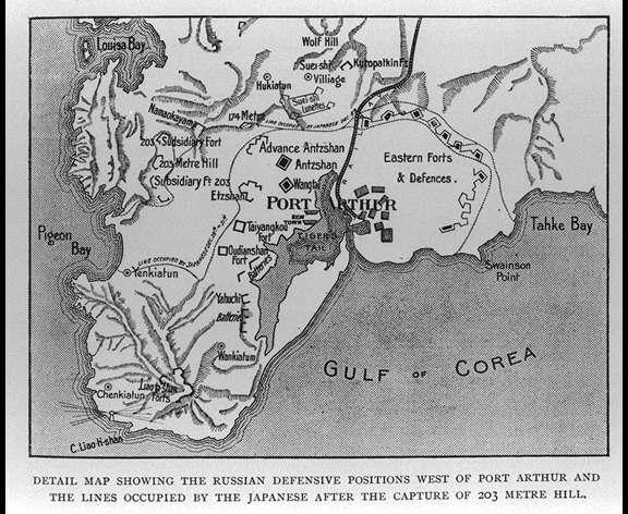
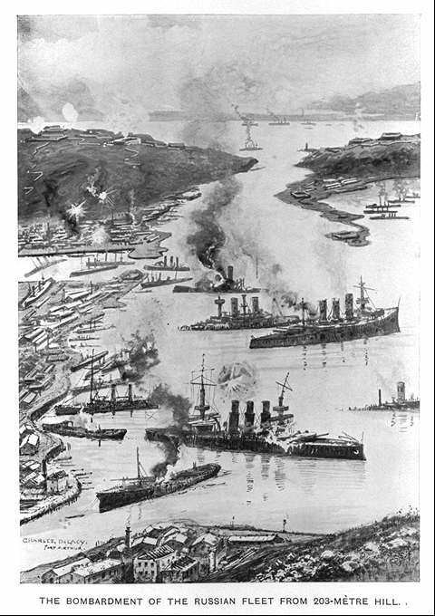
- ポートアーサー(旅順)の西のロシア軍の防衛陣地と203高地占領後の日本軍によって占領された塹壕線を示す詳細な地図/(Detail map showing the Russian defensive positions west of Port Arthur and the lines occupied by the Japanese after the capture of 203 metre Hill.)
ポートアーサー(旅順)の西のロシア軍の防衛陣地と203高地占領後の日本軍によって占領された塹壕線を示す詳細な地図/(Detail map showing the Russian defensive positions west of Port Arthur and the lines occupied by the Japanese after the capture of 203 metre Hill.)
![]()
![]()
関連画像(同一掲載書の他の画像)
全88枚のうち33-40枚を表示 (全11ページ)
| 
| 
|
|
| 
| 
| 
|
| 被写体 | : | ポートアーサー(旅順)の西のロシア軍の防衛陣地と203高地占領後の日本軍によって占領された塹壕線を示す詳細な地図/(Detail map showing the Russian defensive positions west of Port Arthur and the lines occupied by the Japanese after the capture of 203 metre Hill.) |
| 注記 | : | |
| 掲載書名 | : | 極東における戦争:ロシア・日本の戦闘(日露戦争)の歴史 3,4巻 |
| 編集者名 | : | グルー/(Grew, E. Sharpe) |
| 年代 | : | [190-?] |
| 請求番号 | : | DS/517/Gr |
| 図書ID | : | 000123679 |
| GID | : | GH034036 |
| PhotoCD no. | : | 19001 |
国際日本文化研究センター 〒610-1192 京都市西京区御陵大枝山町3丁目2番地
Copyright (c)2002- International Research Center for Japanese Studies, Kyoto, Japan. All rights reserved.
![]()