
- TOP
- キーワードで探す
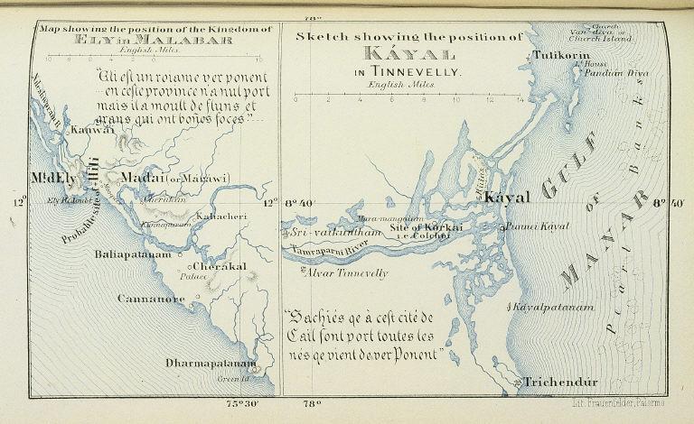
- マラバル海岸のエリ王国の位置を示す地図.ティンネヴェリーのカヤルの位置を示す略図/(Map showing the position of the Kingdom of Ely in Malabar. Sketch showing the position of Kayal in Tinnevelly.)
マラバル海岸のエリ王国の位置を示す地図.ティンネヴェリーのカヤルの位置を示す略図/(Map showing the position of the Kingdom of Ely in Malabar. Sketch showing the position of Kayal in Tinnevelly.)
![]()
![]()
関連画像(同一掲載書の他の画像)
全90枚のうち57-64枚を表示 (全12ページ)
| 被写体 | : | マラバル海岸のエリ王国の位置を示す地図.ティンネヴェリーのカヤルの位置を示す略図/(Map showing the position of the Kingdom of Ely in Malabar. Sketch showing the position of Kayal in Tinnevelly.) |
| 注記 | : | |
| 掲載書名 | : | 東方の王国と驚異に関する,ヴェネチア人マルコ・ポーロ殿の書(東方見聞録) 第2巻 |
| 編集者名 | : | ポーロ(マルコ・ポーロ)/(Polo, Marco, 1254-1323?) |
| 年代 | : | 1875 |
| 請求番号 | : | G/370/Ma |
| 図書ID | : | 001697267 |
| GID | : | GQ011068 |
| PhotoCD no. | : | 408 |
国際日本文化研究センター 〒610-1192 京都市西京区御陵大枝山町3丁目2番地
Copyright (c)2002- International Research Center for Japanese Studies, Kyoto, Japan. All rights reserved.
![]()