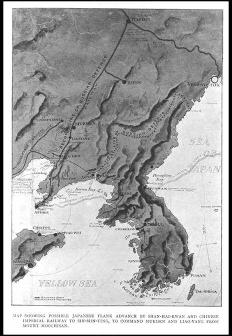
ムーチサン山(?)からムクデン(奉天)とリャオヤン(遼陽)を制するために,シャンハイカン(山海関)とシンミンチン(新民府?)行きの中国帝国鉄道を通る起こりうる日本軍の側面の前進を示している地図/(Map showing possible Japanese flank advance by Shan-hai-kwan and Chinese Imperial Railway to Sin-min-ting, to command Mukden and Liao-yang from Mount Moochisan.)
| 被写体 |
: |
ムーチサン山(?)からムクデン(奉天)とリャオヤン(遼陽)を制するために,シャンハイカン(山海関)とシンミンチン(新民府?)行きの中国帝国鉄道を通る起こりうる日本軍の側面の前進を示している地図/(Map showing possible Japanese flank advance by Shan-hai-kwan and Chinese Imperial Railway to Sin-min-ting, to command Mukden and Liao-yang from Mount Moochisan.) |
| 注記 |
: |
|
| 掲載書名 |
: |
極東における戦争:ロシア・日本の戦闘(日露戦争)の歴史 1,2巻 |
| 編集者名 |
: |
グルー/(Grew, E. Sharpe) |
| 年代 |
: |
[190-?] |
| 請求番号 |
: |
DS/517/Gr |
| 図書ID |
: |
000123661 |
| GID |
: |
GH035085 |
| PhotoCD no. |
: |
20038 |
