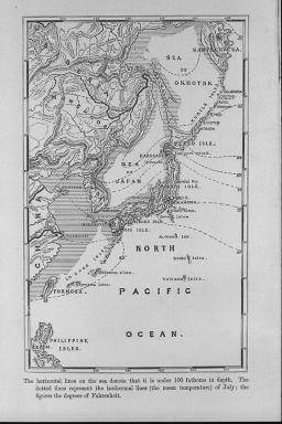
日本帝国の地図.海上の水平の線は水深100尋以上を示している.点線は7月の等温線<平均気温>を示している;数字はカ氏の温度/(Map of the Japanese Empire. The holizontal lines on the sea denote that it is under 100 fathoms in depth. The dotted lines represent the isothermal lines (the mean temperature) of July; the figures the degrees of Fahrenheit.)
| 被写体 |
: |
日本帝国の地図.海上の水平の線は水深100尋以上を示している.点線は7月の等温線<平均気温>を示している;数字はカ氏の温度/(Map of the Japanese Empire. The holizontal lines on the sea denote that it is under 100 fathoms in depth. The dotted lines represent the isothermal lines (the mean temperature) of July; the figures the degrees of Fahrenheit.) |
| 注記 |
: |
|
| 掲載書名 |
: |
日本帝国の鳥類 |
| 編集者名 |
: |
シーボーム/(Seebohm, Henry) |
| 年代 |
: |
1890 |
| 請求番号 |
: |
QL/691/Se |
| 図書ID |
: |
001257401 |
| GID |
: |
GM168004 |
| PhotoCD no. |
: |
282003 |
