
- TOP
- キーワードで探す
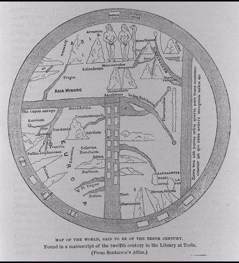
- 10世紀のものといわれる世界地図.トリノの図書館で12世紀の古写本の中に発見された<サンタレムの地図より>/(Map of the world, said to be of the tenth century. Found in a manuscript of the twelfth century in the library at Turin. (From Santarem's Atlas.))
10世紀のものといわれる世界地図.トリノの図書館で12世紀の古写本の中に発見された<サンタレムの地図より>/(Map of the world, said to be of the tenth century. Found in a manuscript of the twelfth century in the library at Turin. (From Santarem's Atlas.))
![]()
![]()
関連画像(同一掲載書の他の画像)
全139枚のうち49-56枚を表示 (全18ページ)
| 
| 
| 
|
| 
| 
| 
|
| 被写体 | : | 10世紀のものといわれる世界地図.トリノの図書館で12世紀の古写本の中に発見された<サンタレムの地図より>/(Map of the world, said to be of the tenth century. Found in a manuscript of the twelfth century in the library at Turin. (From Santarem's Atlas.)) |
| 注記 | : | |
| 掲載書名 | : | アジアとヨーロッパを回るヴェガ号の航海:旧世界北海岸沿いの以前の旅行の歴史的再検討とともに(ヴェガ号航海誌:1878−1880) 第2巻 |
| 編集者名 | : | ノルデンシェルド(ノルデンショルド/ノーデンショルド)/(Nordenskiold, A. E. (Adolf Erik), 1832-1901) |
| 年代 | : | 1881 |
| 請求番号 | : | G/490/No |
| 図書ID | : | 000066134 |
| GID | : | GJ002061 |
| PhotoCD no. | : | 90033 |
国際日本文化研究センター 〒610-1192 京都市西京区御陵大枝山町3丁目2番地
Copyright (c)2002- International Research Center for Japanese Studies, Kyoto, Japan. All rights reserved.
![]()