


- TOP
- Search using keywords
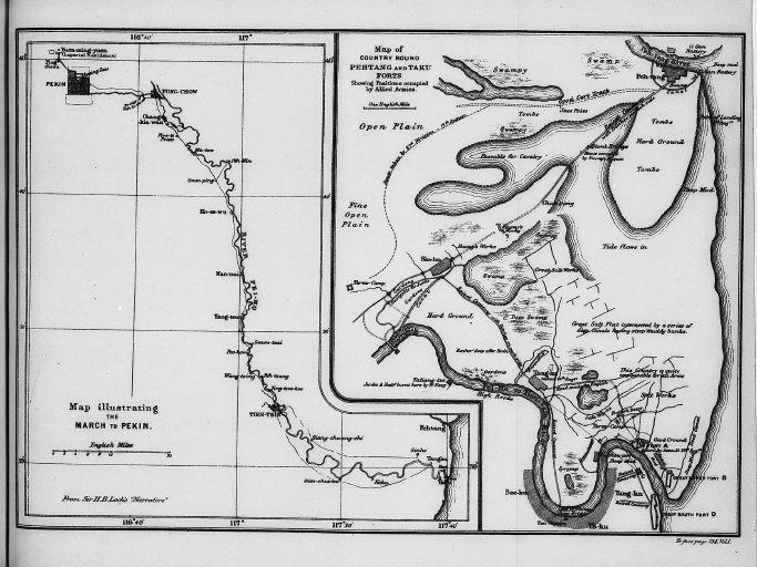
- 北京への行軍を説明する地図.連合軍の占領情勢を説明している北塘と大沽要塞あたりの地図/(Map illustrating the March to Pekin. Map of country round Pehtang and Taku forts showing positions occupied by Allied Armies.)
北京への行軍を説明する地図.連合軍の占領情勢を説明している北塘と大沽要塞あたりの地図/(Map illustrating the March to Pekin. Map of country round Pehtang and Taku forts showing positions occupied by Allied Armies.)


Related Image
Showing 5 of 1-5 Results (total 1page)
| 
| 
| 
|
|
|
| caption | : | 北京への行軍を説明する地図.連合軍の占領情勢を説明している北塘と大沽要塞あたりの地図/(Map illustrating the March to Pekin. Map of country round Pehtang and Taku forts showing positions occupied by Allied Armies.) |
| note | : | |
| book title | : | 中国領事 |
| author | : | レーン・プール/(Lane-Poole, Stanley, 1854-1931) |
| year | : | 1894 |
| Library Number | : | DA/565/Li |
| author | : | 001780063 |
| GID | : | GO035005 |
| PhotoCD no. | : | 374 |


International Research Center for Japanese Studies 3-2 Oeyama-cho, Goryo, Nishikyo-ku, Kyoto 610-1192 Japan
Copyright (c)2002- International Research Center for Japanese Studies, Kyoto, Japan. All rights reserved.